Driving to Acapulco
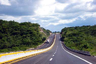
Driving in Mexico can either be peaceful and safe or nerve racking and dangerous. It all depends on you. A popular route is to enter at Nuevo Laredo (the worst part of the trip) and head towards Monterrey and Mexico City. Then you go down the "Autopista del Sol" to Acapulco. This is the easiest and perhaps safest route to Acapulco. It has wide, mostly well-groomed lanes that take you all the way. Your can drive as easily at night as in the US or Canada - that is, if you take the sparsely populated cuotas (toll roads).
Driving on a Mexican highway is no time to be a cheap skate. Though some cuotas can be as expensive as the equivalent of $20 USD for a short stretch of road, they are worth every peso. If you decide to go Mexican-style on the free highways, be prepared to deal with two lane roads with huge trucks bearing down at you head on. The lanes are narrow. The curves are blind. And you may suddenly encounter peasants, burros or chickens in the middle to the road. The distances between gas stations is vague. Pot holes may be chasms, and the spring-breaking speed bumps may seem like they are a foot tall. The roads are often undercut, with no shoulders, and visibility after dusk is minimal. The toll roads have "Green Angels," pickup trucks with mechanics and medical aid that patrol for stranded motorists. There are call boxes. The highway is marked with crosses where fatal accidents have taken place.
If you break down and decide you need to start hiking, pay somebody a deposit to watch your car and promise them three times the amount when you get back. An unattended car on a lonely highway conjures images of vultures picking apart a fresh corpse.
Though subject to change, a trip to Acapulco from Texas runs about about $200 USD in tolls.
When gassing up on the highway, be careful to see that the attendant resets the gas pump to zeros (ceros, SAY-rows) before he starts to pump. Starting you out with $100 pesos or so on the meter is the oldest trick in the book and the gas stations in Mexico are historically slippery. In part this explains why most attendants are women these days; the guys were just too problematic. If they scam you and you figure it out after the fact, there is really nothing you can do. The same goes for watering down the gas and damaging your engine or shorting you (claiming the tank is full when you later find out it is not), giving you the wrong change, etc.
No matter which route you take, make sure to buy Mexican auto insurance. It is not that expensive unless you have an expensive car. You can get it at the border (there will be places to buy it everywhere) and it is s a big help if you get into a tight spot, and such "spots" are not uncommon.
One thing that always shocks people from the US is when they find out that in Mexico there is no law requiring auto insurance. In fact, unless you have a new car or a car under lease, most people do not carry insurance. This is a stark difference from the familiar “let me see your driver’s license, registration, and proof of insurance” routine that has been hard-wired into the mind of every US resident. Once you cross the border you are far from the land of no-fault and have stepped back in time to the days of the Code Napoleon.
So what happens if there's an accident? If there's an accident and it's your fault, they put you in jail until you settle with the injured party. No jury trial, no innocent-until-proven-guilty, no bail. You are guilty, and you must make restitution, and that's is all there is to that. Is it fair? Maybe not. Is it efficient? Absolutely. People settle really fast under such circumstances. What might take years to settle the US can routinely be resolved in a couple days in Mexico. If you have insurance (and you better) the insurance company will handle it for you. The lesson: make sure you have the best insurance available and that you're clear about whom to call in case of an emergency.
Another common and potentially unnerving occurrence is the presence of military checkpoints. In the US the constitution protects us from being stopped by young stone-faced soldiers with machine guns. In Mexico, you actually don't see them often when heading south, but you do see them frequently when heading north. They monitor the north-bound lanes of the major highways to check for contraband ranging from drugs, to guns, to Central Americans. These guys are all business. No mordidas (bribes). They take a quick look and send you on your way.
If you're thinking of driving to Acapulco from the West Cost and tend to panic on long stretches of scary, bad, desolate highway, it's recommended to drive to Arizona and enter at Nogales. Then drive straight down (through Mazatlan) to Guadalajara on the well-groomed, spacious highways. From Guadalajara, head to Mexico City (driving into the city), then down to Acapulco on the toll road (Autopista del Sol).
Two stretches of very tricky road may tempt you, as they seem to be the shortest way when looking at a map. They are not, at least if time, stress, and safety are a concern. The highway between Mexicali and Hermosillo is long, lonely and frought with peril. There are few toll roads, only long stretches of free, open road that takes you through the middle of nowhere (really, nowhere!). There is also a bit of road between Toluca and Cuarnavaca that can be more treacherous even than driving through Mexico City. Starting in Toulca (where the traffic rivals that of Mexico City) you travel through narrow two lane highways, tiny towns, highways full of massive speed bumps and pot holes that seem to come out of nowhere, villages with unpaved roads, down alleys, through town squares, residential neighborhoods, and then through a long section of two-lane aggravation that snakes endlessly through a dense forest before descending on the land eternal of spring, the city of Cuernavaca. If you are the adventurous sort and decide to try these routes, you'll come away feeling like you've gone over Niagara Falls in a barrel and lived to tell about it.
The Autopista del Sol
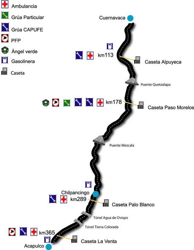
To drive from Mexico City to Acapulco, you go to Cuernavaca, about 85 kilometers away. It takes about an hour to an hour and a half, depending on traffic and what part of Mexico City you start from. In Cuernavaca you pick up the “Autopista del Sol,” a toll road that takes you to Acapulco. The road is not four lanes, but it is theoretically limited access. The Autopista del Sol costs about $504 pesos for normal cars (more for trucks). This includes a toll booth at Tlalpan ($80 pesos), which is technically not part of the Autopista del Sol but is part of the trip. Along the highway are four toll booths (Alpuyeca $52, Paso Morelos $110, Paso Blanco $100, and La Venta $90) and one more at the Maxi-Tunnel ($72) as you arrive into Acapulco. The Autopista del Sol is 296 km long, and in all, coming from Mexico City, the trip is 380 km. This compares with Mexico 95, the so-called “free road,” which is a narrow, two-lane road that is over 400 km long. It is considered a whole lot rougher ride, but it saves nearly $80 USD in tolls for the round trip, calculated at current exchange rates.
The Autopista del Sol was constructed over several years in the 1980’s and 90’s. In 1993 all segments were finally completed. Then, in 1997 special legislation was adopted to pay for more construction and improvements on the Autopista del Sol and several other of the country’s toll roads. Operation and management of the toll road has been transferred to a private company.
If you are planning to drive on this highway, remember this: Acapulco was isolated for centuries from the rest of Mexico because the terrain around it was so hard to cross. The first road to Mexico City was opened only in the 1920’s, reducing travel time from 6 days to a matter of 24 hours! Even though the Autopista del Sol can cut the travel time down to about 4½ hours, the terrain is still a major factor to consider when making the trip. Travelers to Acapulco from Mexico City must cross a high plain and go into and over the Southern Sierra Madre Mountain Range, finally descending sharply down to the sea. This road is not for inexperienced drivers. It has lots of sudden curves and often passes along the side of steep cliffs and gullies. The views are wonderful, but extreme caution is recommended. Traffic accidents are fairly common on the Autopista del Sol, as many drivers coming out of Mexico City, in a hurry to reach the beach, drive too fast for the terrain and weather conditions. During rainy season, keep your eyes open for mudslides.
If you have a breakdown or a flat tire along this road, trucks ("Green Angels" or "Ángeles Verdes") patrol in order to render assistance when needed. Tow trucks, both public and private, are also on call.
Highway 200: The Coastal Road
Highway 200 is Acapulco’s coastal highway. In Acapulco, it's more widely known as Carretera Ixtapa Zihuatanejo (heading north) and Carretera Pinotepa (heading South). It is the coastal freeway that runs from Acapulco to the resort town of Ixtapa and it's more traditional brother Zihuatanejo in the north (the region known as costa grande) and south to Oaxaca (the region known as costa chica). These freeways can be a bit challenging for the inexperienced.
In its full length, Highway 200 takes you from Tapachula in the north (the capital of the coastal state of Nayarit) all the way down to Tepic at the border with Guatemala in the State of Chiapas. The part of Highway 200 that goes from Acapulco up the coast towards Michoacán is the main artery of the shoreline known as “Costa Grande” (Big Coast). From Acapulco, it passes through Pie de la Cuesta right away, and then continues through the towns of Barra de Potosí and Papanoa, finally arriving in Zihuatanejo and then Ixtapa. Then it leaves the state of Guerrero at a small town called La Unión. Lázaro Cárdenas is the name of the first town you reach on this highway after leaving La Unión and crossing the border into Michoacán. The length of this highway from Acapulco to Lázaro Cárdenas is approximately 300 km. Outside of the towns, services on this road are very sparse. It's hard to find a place to pass another vehicle in some stretches, so be sure to give yourself ample time to reach your destination. Plan to stop at a couple of beaches. They are some of the most inviting places on Mexico’s Pacific coast.
To the south and east, Highway 200 connects Acapulco and Barra Vieja to the rest of this part of Guerrero’s coastline, known as “Costa Chica” (Little Coast). The road follows the coast more or less, winding its way towards the state of Oaxaca. After that there’s Chiapas and eventually, the border with Guatemala. Because the Costa Chica is quite mountainous in spots as you go from Acapulco towards Oaxaca, the road often turns inland for a bit, seeking a good route for crossing the mountain ridges as they descend down to the sea from the plains above. The first stop after Acapulco is San Marcos, about 58 km away. A town of about 45,000 inhabitants, noted for its festivals, folk lore, and pretty girls. After San Marcos the next town is Ometepec, close to the border with Oaxaca. Then, just on the other side of the state line is the town of Pinotepa Nacional, which lies 170 km from Acapulco. The resort town of Puerto Escondido is another 90 km past Pinotepa.