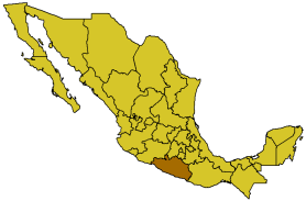
Guerrero
Guerrero first became a state on October 27, 1849. This southern Mexican state covers 64,281 km² and has a population of about 3 million. The state capital of Guerrero is Chilpancingo, known as "Chilpa" to locals. Most people have "been" to Chilpancingo, meaning they have driven through it on a trip between Acapulco and Mexico City. During the period of independence Chilpancingo was briefly the national capital.
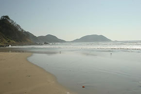
Guerrero is recognized nationally as one of Mexico's poorest states, with an economy based mainly on small-scale agriculture and tourism. The "Triángulo del Sol" (Triangle of the Sun) are the three cities that make up Guerrero's tourist economy: Taxco, which is a small colonial town in the mountains, Ixtapa & Zihuatanejo, which are smallish tourist resorts on the Pacific near the border with Michoacán, and, of course, Acapulco. Iguala is also worth mentioning. It is a small, traditional inland Mexican town in the mountains, about a half hour's drive from Taxco.
Politically, Guerrero is still dominated by the PRD in the cities. The PRI still maintains its strength in the countryside. In 2008 mayoral elections were held in Acapulco, in which the PRI candidate, Miguel Añorve Baños, narrowly beat the PRD candidate, Gloria Sierra. The PAN, the party of Mexico's past two presidents and Mexico's "conservative party" scores little support in Guerrero. Guerrero is known for its hand carved masks, sea turtles, beaches, and its long tradition of "old school" politics.
Located about 450 kilometers south of the Tropic of Cancer (measured at Acapulco), Guerrero is also known for the occasional cyclone (Pacific hurricane or typhoon). It also has some seismic activity. Guerrero's pacific coast region is basically divided into two sections. The Costa Grande, which runs north of Acapulco, and the Costa Chica, which runs to the south of Acapulco towards Oaxaca.
Municipalities
The State of Guerrero is officially divided into 7 main regions: Acapulco, Centro, Costa Chica, Costa Grande, Montaña, Norte, and Tierra Caliente. There are 76 municipalities, roughly the equivalent of counties in the US. They are:
Acapulco De Juarez, Ahuacuotzingo, Ajuchitlan Del Progreso, Alcozauca De Guerrero, Alpoyeca, Apaxtla, Arcelia, Atenango Del Rio, Atlamajalcingo Del Monte, Atlixtac, Atoyac De Alvarez, Ayutla De Los Libres, Azoyu, Benito Juarez, Buenavista De Cuellar, Coahuayutla De Jose Maria Izazaga, Cocula, Copala, Copalillo, Copanatoyac, Coyuca De Benitez, Coyuca De Catalan, Cuajinicuilapa, Cualac, Cuautepec, Cuetzala Del Progreso, Cutzamala De Pinzon, Chilapa De Alvarez, Chilpancingo (Chilpancingo de los Bravo), Florencio Villarreal, General Canuto A Neri, General Heliodoro Castillo, Huamuxtitlan, Huitzuco De Los Figueroa, Iguala De La Independencia, Igualapa, Ixcateopan De Cuauhtemoc, Jose Azueta, Juan R Escudero, Leonardo Bravo, Malinaltepec, Martir De Cuilapan, Metlatonoc, Mochitlan, Olinala, Ometepec, Pedro Ascencio Alquisiras, Petatlan, Pilcaya, Pungarabato, Quechultenango, San Luis Acatlan, San Marcos, San Miguel Totolapan, Taxco De Alarcon, Tecoanapa, Tecpan De Galeana, Teloloapan, Tepecoacuilco De Trujano, Tetipac, Tixtla De Guerrero, Tlacoachistlahuaca, Tlacoapa, Tlalchapa, Tlalixtaquilla De Maldonado, Tlapa de Comonfort, Tlapehuala, La Union, Xalpatlahuac, Xochihuehuetlan, Xochistlahuaca, Zacapocstepec Zapotitlan Tablas, Zirandaro, Zitlala, Eduardo Neri.